NGIT CC has delivered spatial and earth observation solutions for NASA, USAID, RCMRD, NamWater, NORED, ministries and private sector organisations. View our completed GIS, mapping, training, environmental, and research projects.
Risk Based Solutions CC
On the production of different environmental i m p a c t assessment maps, 2009, 2010 and 2011
Ministry of Mines and Energy
Under the Directorate of Geological Survey of Namibia on GIS and EO metadata training, 2011
Triple E Systems Inc (USA)
Based Climate Risk Assessment in Namibia, Including training to academics and community members, 2011 to 2012 to current.
Ministry of Agriculture, Water and Forestry
Outapi State Veterinary Office on provision of Hand-held Global Positioning Systems
RCMRD (REGIONALCENTRE FOR MAPPING OFRESOURCESFOR DEVELOPMENT)
On SERVIR-Eastern and Southern Africa research project, Report writing & Training, 2015
NASA (NATIONAL AERONAUTICS AND SPACE ADMINISTRATION)
On SERVIREastern and Southern Africa research project, Report writing & Training, 2015
MINISTRY OF HEALTH AND SOCIAL SERVICES, Directorate of Environmental Health
For provision of maps representing radiation measure devices – active and planned, 2017
NAMIBIA WATER CORPORATION LTD
On training of staff member in introduction to GIS, Advanced GIS and Environmental Issues in Namibia, 2018, and 2019
MINISTRY OF ENVIRONMENT, FORESTRY AND TOURISM
On Consultancy to develop a module on the climate change MRV components under the Capacity Building Initiative for Transparency Project, 2021 to 2022
NAMIBIA INTEGRATED SERVICES CC
On different topographical and land use maps of Lusese and Sangwali villages in the Zambezi region for village upgrading purpose, 2016
RITTA KHIBA PLANNING CONSULTANTS CC
On the production of different infrastructure and natural resource maps for Windhoek-Rehoboth railway project, 2015
NORED Electricity LTD
On training of staff member on the Implementation of Web GIS for Utilities, 2020
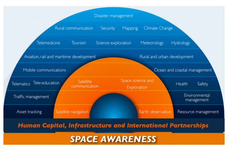
NGIT Cc has operational experience and expertise in various domains of space science and technology. This includes earth observations, Geographical Information Science (GIS), land management and ICT for more than a decade. With a vast technical background, panel of experts and backed with domain knowledge, NGIT Cc has executed many projects in the domains below.
We have carved our own niche in various domains and are substantiated by the projects that we have executed in the areas of space policy, strategy and program development, Higher Education, Research, Training, Land Records, Utilities Sector, Remote Sensing and many Organizations etc… over the last 16 years of our operations. Our footprints are visible both in the international and national ground in the spatial field.